
1946 Map of Antrim
USGS Topo · Published 1952About this map
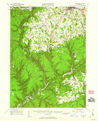
Pine Creek Gorge dominates this mid-century landscape, carving a deep path through the highlands of Tioga County. The map reveals a post-war rural economy transitioning from early industrial roots, as evidenced by the convergence of the Baltimore and Ohio and New York Central railroads. While Wellsboro serves as the regional hub in the north, smaller settlements like Antrim and Morris remain vital centers linked by the Roosevelt Highway. Local genealogists will find significant value in the distribution of family-named landmarks and rural institutions, including the Sherman Sch, the Cedar Run Ch, and numerous remote burial grounds such as Butler Cem and Mt Pleasant Cem. The terrain is punctuated by significant summits like Mount Tom and Texas Mtn, illustrating the steep relief of the Pennsylvania Wilds before the era of modern development.
Find a feature on this map
91 named features on this map. Tap any name to fly to it.
Don’t see what you’re looking for? This feature index may not catch every label — zoom into the map to look around manually.
Map Details
Editions of this 1946 Antrim Map
2 editions found
Other maps of this area

1899 · Gaines
USGS Topo · 1:62,500

1900 · Gaines
USGS Topo · 1:62,500

1900 · Tioga
USGS Topo · 1:62,500

1900 · Elkland
USGS Topo · 1:62,500

1902 · Tioga
USGS Topo · 1:62,500

1921 · Trout Run
USGS Topo · 1:62,500

1923 · Trout Run
USGS Topo · 1:62,500

1925 · Blossburg
USGS Topo · 1:62,500

1927 · Blossburg
USGS Topo · 1:62,500

1937 · Waterville
USGS Topo · 1:48,000