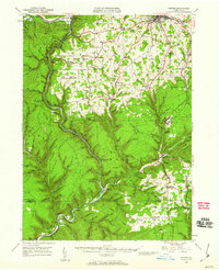
1946 Map of Antrim
USGS Topo · Published 1960About this map
The dramatic incision of the Pine Creek Gorge dominates this mid-century landscape, carving through the high plateaus of the Tioga County and Lycoming County border. The map documents a period when rural industrial footprints remained prominent, from the timber-derived names of Leetonia and Hoytville to the active Baltimore and Ohio and New York rail lines tracing the steep valleys. In the north, the county seat of Wellsboro is shown in detail, including the Wellsboro Country Club and the emerging suburban patterns around Russell Hill.
Find a feature on this map
165 named features on this map. Tap any name to fly to it.
Don’t see what you’re looking for? This feature index may not catch every label — zoom into the map to look around manually.
Map Details
Editions of this 1946 Antrim Map
2 editions found

Other maps of this area

1899 · Gaines
USGS Topo · 1:62,500

1900 · Gaines
USGS Topo · 1:62,500

1900 · Tioga
USGS Topo · 1:62,500

1900 · Elkland
USGS Topo · 1:62,500

1902 · Tioga
USGS Topo · 1:62,500

1921 · Trout Run
USGS Topo · 1:62,500

1923 · Trout Run
USGS Topo · 1:62,500

1925 · Blossburg
USGS Topo · 1:62,500

1927 · Blossburg
USGS Topo · 1:62,500

1937 · Waterville
USGS Topo · 1:48,000