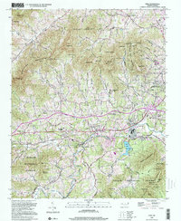
1998 Map of Enka
USGS Topo · Published 2001About this map
Enka Lake and the industrial infrastructure of Enka anchor this landscape during a period of sustained suburban transition in Buncombe County. The map details the complex geography of the Pisgah National Forest and the Pisgah Game Lands, where high elevations like Potato Knob and Spivey Mtn give way to the residential corridors of Candler Heights and Woodside Hills. The layout of Enka Village and the nearby tailings ponds reflect the area's mid-century manufacturing roots, while the numerous local congregations, such as Snow Hill Ch and Mt Moriah Church, provide a clear map of the region's social fabric.
Find a feature on this map
100 named features on this map. Tap any name to fly to it.
Don’t see what you’re looking for? This feature index may not catch every label — zoom into the map to look around manually.
Map Details
Editions of this 1998 Enka Map
This is the sole edition of this map. No revisions or reprints were ever made.
Other maps of this area

1894 · Asheville
USGS Topo · 1:125,000

1901 · Asheville
USGS Topo · 1:125,000

1905 · Pisgah
USGS Topo · 1:125,000

1906 · Pisgah
USGS Topo · 1:125,000

1935 · Cruso
USGS Topo · 1:24,000

1935 · Canton
USGS Topo · 1:24,000

1936 · Sandymush
USGS Topo · 1:24,000

1936 · Enka
USGS Topo · 1:24,000

1936 · Weaverville
USGS Topo · 1:24,000

1936 · Skyland
USGS Topo · 1:24,000