
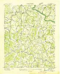
1936 Map of Sandymush
USGS Topo · Published 1936About this map
The high ridges of Pisgah National Forest and Newfound Mountain dominate this mid-1930s landscape, where small rural communities are defined by their proximity to winding creeks and mountain gaps. The map reveals a deeply social geography for the era, centered on neighborhood anchors like the Sandymush Brick Ch, Sandymush Sch, and Lusk Chapel. While State Highway No 213 and State Highway No 209 provide the primary connections through the terrain, the presence of Gentrys Mill and numerous smaller dwellings along the Sandymush Creek and Spring Creek watersheds illustrates a community still largely oriented toward local waterpower and small-scale agriculture. The boundary between Madison and Buncombe Counties cuts through the northern section, marking a divide between the drainages of Little Pine Creek and the valley of Canto.
Find a feature on this map
63 named features on this map. Tap any name to fly to it.
Don’t see what you’re looking for? This feature index may not catch every label — zoom into the map to look around manually.
Map Details
Editions of this 1936 Sandymush Map
This is the sole edition of this map. No revisions or reprints were ever made.
Other maps of this area

1894 · Asheville
USGS Topo · 1:125,000

1901 · Asheville
USGS Topo · 1:125,000

1935 · Canton
USGS Topo · 1:24,000

1935 · Clyde
USGS Topo · 1:24,000

1935 · Spring Creek
USGS Topo · 1:24,000

1935 · Lemon Gap
USGS Topo · 1:24,000

1936 · Marshall
USGS Topo · 1:24,000

1936 · Enka
USGS Topo · 1:24,000

1936 · Hepco
USGS Topo · 1:24,000
1936 · Leicester
USGS Topo · 1:24,000