
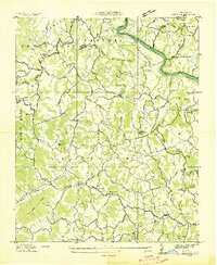
1936 Map of Marshall
USGS Topo · Published 1936About this map
Marshall sits along a sharp bend of the French Broad River, serving as a central hub in this mid-1930s topographical study. The river corridor is the lifeblood of the region, carrying the Southern Railway and State Highway Nos 25 & 70 past industrial and civic landmarks like Redmon Dam and the State Prison Camp. The presence of Blennerhassett Island at the town's core highlights the unique riverine geography that dictated local development.
Find a feature on this map
84 named features on this map. Tap any name to fly to it.
Don’t see what you’re looking for? This feature index may not catch every label — zoom into the map to look around manually.
Map Details
Editions of this 1936 Marshall Map
This is the sole edition of this map. No revisions or reprints were ever made.
Other maps of this area

1894 · Asheville
USGS Topo · 1:125,000

1901 · Asheville
USGS Topo · 1:125,000

1935 · Hot Springs
USGS Topo · 1:24,000

1935 · Spring Creek
USGS Topo · 1:24,000

1936 · Sandymush
USGS Topo · 1:24,000

1936 · Sams Gap
USGS Topo · 1:24,000

1936 · White Rock
USGS Topo · 1:24,000

1936 · Weaverville
USGS Topo · 1:24,000

1936 · Mars Hill
USGS Topo · 1:24,000
1936 · Leicester
USGS Topo · 1:24,000