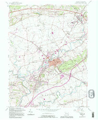
1992 Map of Ephrata
USGS Topo · Published 1995About this map
Ephrata stands as the central hub of this northern Lancaster County landscape, where the Reading RR corridors and modern highways intersect a region deeply rooted in Pennsylvania German heritage. The map documents a dense network of cross-road settlements like Schoeneck, Reamstown, and Akron, many defined by their proximity to local watercourses like Cocalico Creek and the Conestoga River. The abundance of small community landmarks, including Indiantown Ch, Mellingers Ch, and numerous family-named schoolhouses such as the Hans Graf Sch, suggests a social landscape built on close-knit townships and rural school districts. Topographically, the area is anchored by the rising profile of Ephrata Mountain and Mt Airy, which overlook the surrounding farmland and the path of the Pennsylvania Turnpike as it cuts across the northern townships.
Find a feature on this map
75 named features on this map. Tap any name to fly to it.
Don’t see what you’re looking for? This feature index may not catch every label — zoom into the map to look around manually.
Map Details
Editions of this 1992 Ephrata Map
This is the sole edition of this map. No revisions or reprints were ever made.
Other maps of this area

1891 · Lebanon
USGS Topo · 1:62,500

1893 · Lebanon
USGS Topo · 1:62,500

1899 · Lebanon
USGS Topo · 1:62,500

1902 · Wernersville
USGS Topo · 1:62,500

1902 · Lancaster
USGS Topo · 1:62,500

1904 · Lancaster
USGS Topo · 1:62,500

1906 · New Holland
USGS Topo · 1:62,500

1908 · New Holland
USGS Topo · 1:62,500

1941 · New Holland
USGS Topo · 1:62,500

1943 · Lancaster
USGS Topo · 1:62,500