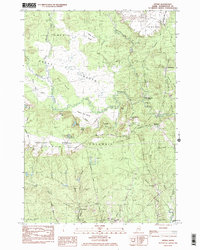
1984 Map of Epping
USGS Topo · Published 1985About this map
Great Heath dominates the northern reaches of this coastal Maine landscape, where the Pleasant River snakes through a complex network of wetlands and islands like Pine Island. This 1984 survey reveals a transition from the vast peatlands and Blueberry Barrens to the small village clusters of Epping, Georgetown, and Tibbettstown. The geography is defined by its water and woods, showing the influence of the Maine Central rail line and the Harrington River on local orientation. Genealogists can find several family-named landmarks and burial grounds, including Malley Hill Cem and Forest Hills Cem, alongside the Little River Ch at Little River Corner. The map captures the working landscape of Washington County, from the Silica Ponds to the high ground of Pea Ridge, before modern development altered these traditional township boundaries.
Find a feature on this map
49 named features on this map. Tap any name to fly to it.
Don’t see what you’re looking for? This feature index may not catch every label — zoom into the map to look around manually.
Map Details
Editions of this 1984 Epping Map
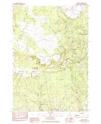
2 editions found
Other maps of this area

1902 · Cherryfield
USGS Topo · 1:62,500

1904 · Cherryfield
USGS Topo · 1:62,500

1921 · Columbia Falls
USGS Topo · 1:62,500

1921 · Columbia Falls
USGS Topo · 1:62,500

1941 · Columbia Falls
USGS Topo · 1:62,500

1941 · Wesley
USGS Topo · 1:62,500

1941 · Tug Mountain
USGS Topo · 1:62,500

1942 · Cherryfield
USGS Topo · 1:62,500

1942 · Columbia Falls
USGS Topo · 1:62,500

1943 · Tug Mountain
USGS Topo · 1:62,500