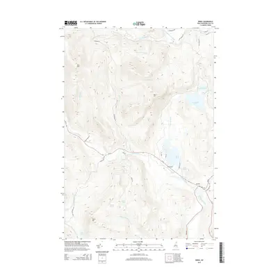
2015 Map of Errol
USGS Topo · Published 2015About this map
The Androscoggin River and Clear Stream converge at the settlement of Errol, a critical junction in this northern New Hampshire landscape. In this 2015 U.S. Geological Survey representation, the town is oriented around the intersection of RT 26 and Berlin RD, serving as a gateway to the mountainous terrain and water bodies of Coos County. Significant peaks such as Rice Mtn and Black Mtn dominate the high ground, while the Swift Diamond River carves through the northern reaches of the quadrangle. The map reveals a network of timber and access roads including Corser Brook RD and Swift Diamond RD, which navigate the steep elevations between valley floors and remote water features like Greenough Pond and Signal Pond. For those interested in the region's industrial or recreational history, the presence of the Errol Airport and Ellingwood Falls highlights the intersection of transportation and natural river features near the village center.
Find a feature on this map
43 named features on this map. Tap any name to fly to it.
Don’t see what you’re looking for? This feature index may not catch every label — zoom into the map to look around manually.
Map Details
Editions of this 2015 Errol Map
This is the sole edition of this map. No revisions or reprints were ever made.
Other maps of this area

1930 · Milan
USGS Topo · 1:62,500

1930 · Percy
USGS Topo · 1:62,500

1930 · Dixville
USGS Topo · 1:62,500

1930 · Errol
USGS Topo · 1:62,500

1933 · Dixville
USGS Topo · 1:62,500

1933 · Milan
USGS Topo · 1:62,500

1934 · Percy
USGS Topo · 1:62,500

1934 · Dixville
USGS Topo · 1:62,500

1934 · Errol
USGS Topo · 1:62,500

1934 · Milan
USGS Topo · 1:62,500