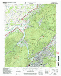
2003 Map of Erwin
USGS Topo · Published 2004About this map
Erwin stands as a central industrial and transport hub at the base of Cherokee Mountain, where the Nolichucky River carves a path through the steep Appalachian terrain. This 2003 revision reflects a landscape defined by the CSX Transportation railroad corridor and the Cherokee National Forest. The map documents a cluster of rural settlements and family-oriented landmarks along the river valley, including Garber, Keplinger, and Embreeville. Local history and genealogy are anchored by numerous small burial grounds and religious sites, such as the Evergreen Cemetery and Cherokee Church. High-elevation landmarks like Devils Looking Glass and Shinbone Rock overlook the winding river, which forms the notable horseshoe bend near Bumpus Cove Creek. The inclusion of modern infrastructure, such as the Communication Tower and Settling Ponds, juxtaposed with the old Lamar School, illustrates the area's continued evolution into the 21st century.
Find a feature on this map
69 named features on this map. Tap any name to fly to it.
Don’t see what you’re looking for? This feature index may not catch every label — zoom into the map to look around manually.
Map Details
Editions of this 2003 Erwin Map
This is the sole edition of this map. No revisions or reprints were ever made.
Other maps of this area

1891 · Roan Mountain
USGS Topo · 1:125,000

1892 · Greeneville
USGS Topo · 1:125,000

1894 · Roan Mountain
USGS Topo · 1:125,000

1896 · Greeneville
USGS Topo · 1:125,000

1904 · Roan Mountain
USGS Topo · 1:125,000

1904 · Greeneville
USGS Topo · 1:125,000

1935 · Chestoa
USGS Topo · 1:24,000

1935 · Leesburg
USGS Topo · 1:24,000

1935 · Erwin
USGS Topo · 1:24,000

1935 · Huntdale
USGS Topo · 1:24,000