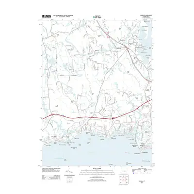
2012 Map of Essex
USGS Topo · Published 2012About this map
Ivoryton and Centerbrook anchor this coastal landscape where the Falls River meets the Connecticut River estuary. The map reveals a dense network of shoreline communities and maritime landmarks, including the Essex Reef Light and the Essex Town Dock near Potapaug Point. Further inland, the presence of Incarnation Camp and Camp Pequot suggests the area's long-standing role as a recreational retreat, while the path of the Valley Railroad traces the historic transportation corridor along the riverbank.
Find a feature on this map
267 named features on this map. Tap any name to fly to it.
Don’t see what you’re looking for? This feature index may not catch every label — zoom into the map to look around manually.
Map Details
Editions of this 2012 Essex Map
This is the sole edition of this map. No revisions or reprints were ever made.
Other maps of this area

1893 · Guilford
USGS Topo · 1:62,500

1893 · Saybrook
USGS Topo · 1:62,500

1941 · Lyme
USGS Topo · 1:31,680

1944 · Essex
USGS Topo · 1:31,680

1944 · Deep River
USGS Topo · 1:31,680
1947 · Orient
USGS Topo · 1:24,000

1947 · Hartford
USGS Topo · 1:250,000

1948 · Hartford
USGS Topo · 1:250,000
1951 · Lyme
USGS Topo · 1:31,680

1951 · Clinton
USGS Topo · 1:31,680