
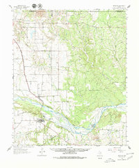
1961 Map of Estelline
USGS Topo · Published 1963About this map
The Prairie Dog Town Fork Red River carves a wide, braided path across this landscape, defining the character of Hall and Childress counties during the early 1960s. The town of Estelline serves as a central hub, situated where the Fort Worth and Denver and Burlington railroads converge at Plains Junction. This intersection of rail lines and the presence of the Estelline Spring highlight the area's historical reliance on both transportation networks and local water sources for survival in the Texas Panhandle.
Find a feature on this map
23 named features on this map. Tap any name to fly to it.
Don’t see what you’re looking for? This feature index may not catch every label — zoom into the map to look around manually.
Map Details
Editions of this 1961 Estelline Map
2 editions found
Other maps of this area

1954 · Plainview
USGS Topo · 1:250,000

1958 · Plainview
USGS Topo · 1:250,000

1960 · Loco
USGS Topo · 1:62,500

1961 · Memphis
USGS Topo · 1:62,500

1963 · Giles
USGS Topo · 1:24,000

1964 · Rolla SW
USGS Topo · 1:24,000

1964 · Wellington
USGS Topo · 1:24,000

1964 · Rolla
USGS Topo · 1:24,000

1967 · Tell North
USGS Topo · 1:24,000

1967 · Badger Nest Tank
USGS Topo · 1:24,000