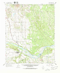
1961 Map of Estelline
USGS Topo · Published 1980About this map
Estelline and the surrounding Texas Panhandle landscape are defined by the wide, braided path of the Prairie Dog Town Fork Red River. The settlement pattern follows the Fort Worth and Denver (Burlington) railroad line, which runs northwest to southeast through Newlin and Plains Junction. This corridor represents the primary infrastructure of the region during the mid-20th century, connecting small ranching communities to larger markets.
Find a feature on this map
21 named features on this map. Tap any name to fly to it.
Don’t see what you’re looking for? This feature index may not catch every label — zoom into the map to look around manually.
Map Details
Editions of this 1961 Estelline Map
2 editions found
Other maps of this area

1954 · Plainview
USGS Topo · 1:250,000

1958 · Plainview
USGS Topo · 1:250,000

1960 · Loco
USGS Topo · 1:62,500

1961 · Memphis
USGS Topo · 1:62,500

1961 · Estelline
USGS Topo · 1:62,500

1963 · Giles
USGS Topo · 1:24,000

1964 · Rolla SW
USGS Topo · 1:24,000

1964 · Wellington
USGS Topo · 1:24,000

1964 · Rolla
USGS Topo · 1:24,000

1967 · Tell North
USGS Topo · 1:24,000