
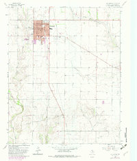
1964 Map of Wellington
USGS Topo · Published 1967About this map
Wellington serves as the focal point of this mid-1960s study, revealing a town defined by its role as a regional hub in Collingsworth County. The street grid is clearly delineated, centering on the Courthouse and extending south to Fifteenth St, while the Fort Worth and Denver railroad cuts through the landscape, anchoring the local transit economy. Significant community landmarks from the era include the High Sch, the Drive-in Theater, and Marian Airpark, illustrating the post-war infrastructure of this Texas Panhandle community.
Find a feature on this map
23 named features on this map. Tap any name to fly to it.
Don’t see what you’re looking for? This feature index may not catch every label — zoom into the map to look around manually.
Map Details
Editions of this 1964 Wellington Map
2 editions found
Other maps of this area

1954 · Plainview
USGS Topo · 1:250,000

1958 · Plainview
USGS Topo · 1:250,000

1959 · Wellington NW
USGS Topo · 1:24,000

1959 · Shinnery Creek
USGS Topo · 1:24,000

1960 · Loco
USGS Topo · 1:62,500

1961 · Estelline
USGS Topo · 1:62,500

1964 · Rolla NE
USGS Topo · 1:24,000

1964 · Dodson
USGS Topo · 1:24,000

1964 · Rolla
USGS Topo · 1:24,000
1984 · Arlie
USGS Topo · 1:24,000