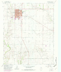
1964 Map of Wellington
USGS Topo · Published 1982About this map
The town of Wellington serves as a prominent hub on this Panhandle landscape, where the local street grid centers on a Courthouse and High Sch. The Fort Worth and Denver railroad cuts a straight diagonal through the terrain, illustrating the critical role of rail transport in connecting these agricultural plains to larger markets. To the south, Fresno appears as a smaller outlying point of interest amidst a network of seasonal watercourses including Log Creek, Buck Creek, and Sand Creek. Cultural landmarks such as the Old Wellington Cem and Marian Airpark offer specific points for genealogical and local historical research. The presence of Gravel Pits in the southern portion of the quadrangle points to the local extractive industries that supported the region's infrastructure during the mid-20th century.
Find a feature on this map
25 named features on this map. Tap any name to fly to it.
Don’t see what you’re looking for? This feature index may not catch every label — zoom into the map to look around manually.
Map Details
Editions of this 1964 Wellington Map
2 editions found
Other maps of this area

1954 · Plainview
USGS Topo · 1:250,000

1958 · Plainview
USGS Topo · 1:250,000

1959 · Wellington NW
USGS Topo · 1:24,000

1959 · Shinnery Creek
USGS Topo · 1:24,000

1960 · Loco
USGS Topo · 1:62,500

1961 · Estelline
USGS Topo · 1:62,500

1964 · Rolla NE
USGS Topo · 1:24,000

1964 · Wellington
USGS Topo · 1:24,000

1964 · Dodson
USGS Topo · 1:24,000

1964 · Rolla
USGS Topo · 1:24,000