
1967 Map of Tell North
USGS Topo · Published 1969About this map
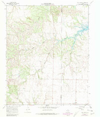
The small community of Tell anchors the southeastern corner of this West Texas landscape, positioned just above the boundary of Hall and Childress counties. This 1960s survey captures a transition in the local terrain, where the headwaters of several drainage systems converge. The branching forks of North Baylor Creek, South Baylor Creek, and Baylor Creek create a complex network of draws that dominate the central topography, eventually feeding into Baylor Lake in the northeast. This water-focused landscape is marked by numerous wells and intermittent streams like Rustlers Creek and Cox Creek, reflecting the essential ranching and agricultural infrastructure of the Texas Panhandle. Beyond the settlement at Tell, evidence of local industry is visible in the scattered Gravel Pits and the presence of a local cemetery, providing valuable points of reference for family historians studying this rural district.
Find a feature on this map
12 named features on this map. Tap any name to fly to it.
Don’t see what you’re looking for? This feature index may not catch every label — zoom into the map to look around manually.
Map Details
Editions of this 1967 Tell North Map
2 editions found
Other maps of this area

1954 · Plainview
USGS Topo · 1:250,000

1958 · Plainview
USGS Topo · 1:250,000

1961 · Memphis
USGS Topo · 1:62,500

1961 · Estelline
USGS Topo · 1:62,500

1967 · Tell South
USGS Topo · 1:24,000

1967 · Hell Roaring Creek
USGS Topo · 1:24,000

1967 · Badger Nest Tank
USGS Topo · 1:24,000

1967 · Northfield
USGS Topo · 1:24,000

1967 · Carey
USGS Topo · 1:24,000

1976 · Memphis SE
USGS Topo · 1:24,000