
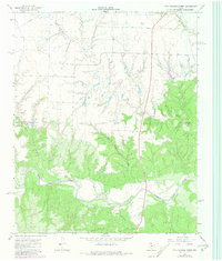
1967 Map of Hell Roaring Creek
USGS Topo · Published 1969About this map
The North Pease River carves a broad valley through the southern half of this Panhandle landscape, where the confluence of several major drainage systems defines the local geography. In the late 1960s, this area on the Childress Co Cottle Co border was characterized by a high degree of erosion, with the winding paths of Hell Roaring Creek and Shores Creek feeding into the larger river system from the north. The presence of a Radio Facility and a scattered Well indicate the light human footprint on this terrain. An Indefinite Boundary runs through the central portion of the map, suggesting the complexities of surveying this dissected land during the mid-century. This map captures the intricate network of seasonal waterways including Sweetwater Creek and Devils Creek, which provide a clear picture of the hydrological patterns of the region before further modern developments.
Find a feature on this map
9 named features on this map. Tap any name to fly to it.
Don’t see what you’re looking for? This feature index may not catch every label — zoom into the map to look around manually.
Map Details
Editions of this 1967 Hell Roaring Creek Map
2 editions found
Other maps of this area

1954 · Plainview
USGS Topo · 1:250,000

1958 · Plainview
USGS Topo · 1:250,000

1966 · Cee Vee
USGS Topo · 1:24,000

1967 · Buckle L Ranch
USGS Topo · 1:24,000

1967 · Tell South
USGS Topo · 1:24,000

1967 · Tell North
USGS Topo · 1:24,000

1967 · Dunlap
USGS Topo · 1:24,000

1967 · Childress
USGS Topo · 1:24,000

1967 · Carey
USGS Topo · 1:24,000
1967 · Swearingen
USGS Topo · 1:24,000