
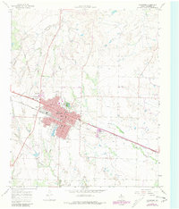
1967 Map of Childress
USGS Topo · Published 1969About this map
The city of Childress serves as a significant regional hub in the Texas Panhandle, defined by its position at the intersection of the Fort Worth and Denver railroad and major highways. During the late 1960s, the community layout reveals a robust public infrastructure, including multiple educational facilities like Wilson Sch, East Ward Sch, and Robert E Lee Sch. The town's social and recreational life is centered around Fair Park, the Rodeo Ground, and the Childress Country Club to the north.
Find a feature on this map
23 named features on this map. Tap any name to fly to it.
Don’t see what you’re looking for? This feature index may not catch every label — zoom into the map to look around manually.
Map Details
Editions of this 1967 Childress Map
2 editions found
Other maps of this area

1954 · Plainview
USGS Topo · 1:250,000

1958 · Plainview
USGS Topo · 1:250,000

1960 · Loco
USGS Topo · 1:62,500

1961 · Estelline
USGS Topo · 1:62,500

1967 · Buckle L Ranch
USGS Topo · 1:24,000

1967 · Hell Roaring Creek
USGS Topo · 1:24,000

1967 · Kirkland South
USGS Topo · 1:24,000

1967 · Kirkland North
USGS Topo · 1:24,000

1967 · Carey
USGS Topo · 1:24,000
1985 · Garden Valley
USGS Topo · 1:24,000