
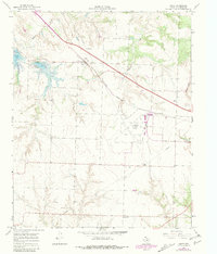
1967 Map of Carey
USGS Topo · Published 1970About this map
Carey and the surrounding plains of the Texas Panhandle appear here in the mid-1960s, a landscape defined by ranching, water management, and transportation. The community of Carey sits along the Fort Worth and Denver railroad, which cuts a sharp diagonal across the terrain alongside a major roadway. To the west, the impoundments of Lake Childress and Baylor Lake contrast with the seasonal drainage of Baylor Creek and Grassy Creek, highlighting the vital importance of surface water in this semi-arid region. Local infrastructure is well-documented, from the Childress Municipal Airport and a Pumping Sta to the Carey Cem located south of the main settlement. Cultural markers of the era are also present, including a Drive-in Theater near the eastern edge of the survey. The map reveals a transition toward modernized transit and utility systems, with a prominent Pipeline and high-voltage lines traversing the rolling topography toward High Point.
Find a feature on this map
13 named features on this map. Tap any name to fly to it.
Don’t see what you’re looking for? This feature index may not catch every label — zoom into the map to look around manually.
Map Details
Editions of this 1967 Carey Map
2 editions found
Other maps of this area

1954 · Plainview
USGS Topo · 1:250,000

1958 · Plainview
USGS Topo · 1:250,000

1960 · Loco
USGS Topo · 1:62,500

1961 · Estelline
USGS Topo · 1:62,500

1967 · Buckle L Ranch
USGS Topo · 1:24,000

1967 · Tell South
USGS Topo · 1:24,000

1967 · Hell Roaring Creek
USGS Topo · 1:24,000

1967 · Tell North
USGS Topo · 1:24,000

1967 · Childress
USGS Topo · 1:24,000
1985 · Estelline SE
USGS Topo · 1:24,000