
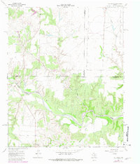
1967 Map of Tell South
USGS Topo · Published 1969About this map
The North Pease River carves a deep, winding path through the heart of this landscape, its complex oxbows and alluvial flats contrasting with the surrounding plateaus. Located at the intersection of Hall, Cottle, and Childress counties, the area is defined by a dendritic drainage network where seasonal waterways like Running Water Creek and Devils Creek feed into the primary river valley. The terrain reveals a rural economy based on land management and resource extraction, evidenced by various Wells and local Gravel Pits located near the riverbank. This 1967 survey also highlights the boundary complexities of the region, including the Childress County and Cottle County Independent Boundary. A modern Pipeline traverses the northern section, cutting across the natural drainages of Joe Lake Cr and Brewster Creek, marking the integration of industrial infrastructure into this Texas Panhandle ranching environment.
Find a feature on this map
13 named features on this map. Tap any name to fly to it.
Don’t see what you’re looking for? This feature index may not catch every label — zoom into the map to look around manually.
Map Details
Editions of this 1967 Tell South Map
2 editions found
Other maps of this area

1954 · Plainview
USGS Topo · 1:250,000

1958 · Plainview
USGS Topo · 1:250,000

1966 · Fields Canyon
USGS Topo · 1:24,000

1966 · Cee Vee
USGS Topo · 1:24,000

1967 · Hell Roaring Creek
USGS Topo · 1:24,000

1967 · Tell North
USGS Topo · 1:24,000

1967 · Dunlap
USGS Topo · 1:24,000

1967 · Badger Nest Tank
USGS Topo · 1:24,000

1967 · Northfield
USGS Topo · 1:24,000

1967 · Carey
USGS Topo · 1:24,000