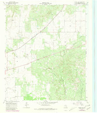
1967 Map of Moons Camp
USGS Topo · Published 1981About this map
Swearingen serves as a focal point in this northwestern Texas landscape, situated along the Quanah Acme and Pacific railroad line. The terrain is defined by a dendritic network of seasonal drainages, including Cottonwood Creek and Shorty Creek, which carve through the plains. The presence of livestock infrastructure is evident through named landmarks such as Red Tower Windmill and Divide Windmill, reflecting the ranching heritage of Cottle County during the mid-20th century.
Find a feature on this map
14 named features on this map. Tap any name to fly to it.
Don’t see what you’re looking for? This feature index may not catch every label — zoom into the map to look around manually.
Map Details
Editions of this 1967 Moons Camp Map
2 editions found
Other maps of this area

1954 · Lubbock
USGS Topo · 1:250,000

1954 · Plainview
USGS Topo · 1:250,000

1958 · Plainview
USGS Topo · 1:250,000

1967 · Dunlap
USGS Topo · 1:24,000

1967 · Triangle Ranch
USGS Topo · 1:24,000
1967 · Baker
USGS Topo · 1:24,000

1967 · Paducah
USGS Topo · 1:24,000

1967 · Moons Camp
USGS Topo · 1:24,000
1967 · Swearingen
USGS Topo · 1:24,000

1968 · Y Ranch
USGS Topo · 1:24,000