Old Maps of Cottle County, Texas
Explore 175 old maps of Cottle County, spanning from 1927 to today. These high-resolution historic maps reveal how streets, neighborhoods, landmarks, and natural features evolved over time — perfect for genealogy, metal detecting, research, and local history exploration.
What you can do with these maps:
- See how Cottle County changed over time: Compare historical maps to modern-day views to trace roads, homesites, rail lines & more.
- View detailed metadata: Each map includes creators, publishers, year, scale, and archive source.
- Overlay maps with satellite & LiDAR: Visualize the past alongside modern tools to explore terrain & human change.
- Trusted historical sources: Maps sourced from the USGS, Library of Congress, and other archives.
- Access maps your way: View online, download high-res files, or order prints for personal or research use.
Start exploring old maps of Cottle County to uncover forgotten places, hidden landmarks, and the deep history beneath your feet.
Cottle County, TX maps
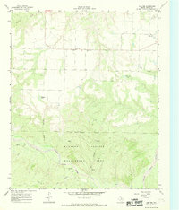
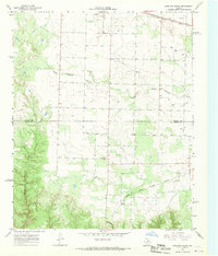
(175)- 1927 Map of Quanah 3-b
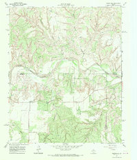
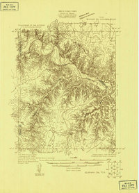 1927 Quanah 3-b1927 Print · USGSThe North Texas plains meet the winding Pease River during the late 1920s as the regional county lines were being precisely defined. Researchers can trace the exact boundaries of Cottle, Hardeman, and Foard counties across this early aerial-assisted survey.
 - 1932 Map of Vivian
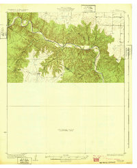 1932 Vivian1932 Print · USGSThe winding valley of the Pease River dominates this north Texas landscape as it appeared in the early thirties. Local history researchers can trace early county lines and rural landmarks like the Forestburg Sch and Teacup Mountain.2 unique versions available
 - 1954 Map of Lubbock, 1958 Print
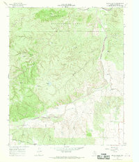
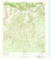
 1954 Lubbock1958 Print · USGSThe High Plains and Caprock region of West Texas come alive in the mid-1950s, showing a landscape defined by oil discovery and the Brazos River headwaters. Genealogists and historians can trace rail-connected towns like Roaring Springs, find the Pleasant Valley church, or locate family-named landmarks such as Soldier Mound.4 unique versions available
 - 1954 Map of Plainview, 1966 Print
 1954 Plainview1966 Print · USGSThe Texas Panhandle and the rugged Caprock Escarpment appear in detail as the region's agricultural and rail networks reached their mid-century peak. Trace family roots and old land patterns through the canyons and plains near Plainview, Palo Duro State Park, and Childress.3 unique versions available
 - 1955 Map of Lawton, 1958 Print
 1955 Lawton1958 Print · USGSSouthwestern Oklahoma and North Texas are shown here in the mid-fifties, dominated by the Wichita Mountains and the vital Red River watershed. Genealogists and historians can trace the foundations of Lawton alongside rural landmarks like Rainy Mountain Church and Pleasant Hill School.5 unique versions available
 - 1958 Map of Plainview
 1958 Plainview1958 Print · USGSThe High Plains and Caprock Escarpment meet in the late fifties, showcasing the ranching and rail networks of the Texas Panhandle. Trace family roots and vanished stops along the Panhandle and Santa Fe railroad through Plainview, Silverton, and Matador.
 - 1960 Map of Goodlett, 1962 Print
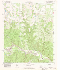
 1960 Goodlett1962 Print · USGSHardeman County at the dawn of the 1960s was a landscape defined by the Red River and a busy network of converging rail lines. Researchers can trace the layouts of small communities like Goodlett and Punkin Center or locate rural burial grounds including Elba Cem and Johnson Cem.2 unique versions available
 - 1960 Map of Teacup Mountain, 1962 Print
 1960 Teacup Mountain1962 Print · USGSFoard and Hardeman counties are captured in the early sixties as they were shaped by the winding Pease River. Local historians can trace family landmarks and geographic features like Teacup Mountain, Sugarloaf Mountain, and the remote Oil Well site.
 - 1966 Map of Fields Canyon
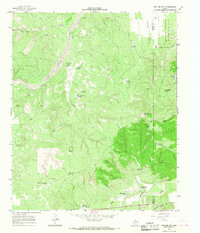
 1966 Fields Canyon1966 Print · USGSThe ranchlands and river breaks of the Texas Panhandle are captured here during the mid-1960s. Genealogists and local historians can trace family-named landmarks like Leary Flat, the Lucky Knob Windmill, and the expanse of the Matador Wildlife Management Area.2 unique versions available
 - 1966 Map of Cee Vee, 1968 Print
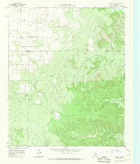
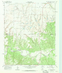
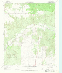
 1966 Cee Vee1968 Print · USGSCottle County ranching and the Matador breaks are preserved here in the mid-1960s. Trace the rural community at Cee Vee, the Haven of Rest Cem, and scattered landmarks like Samson Windmill along the Middle Pease River.2 unique versions available
 - 1966 Map of Tee Pee City, 1968 Print
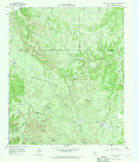
 1966 Tee Pee City1968 Print · USGSThe ranching country of the Texas Rolling Plains is captured here in the mid-1960s, centered on the historic site of Tee Pee City. Researchers can trace the ranching infrastructure of the era, from the Quanah Acme and Pacific rail line to isolated features like the Historical Marker and Schweitzer Windmill.2 unique versions available
 - 1966 Map of Chalk SW, 1969 Print
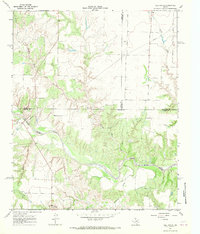
 1966 Chalk SW1969 Print · USGSKing and Cottle counties were defined by cattle ranching and early oil exploration during the mid-sixties. Researchers can trace the boundaries of the J Y Ranch West Camp, locate the Shinnery Cem, and follow the Middle Fork Wichita River.
 - 1966 Map of Lowrance Mountain, 1969 Print
 1966 Lowrance Mountain1969 Print · USGSThe Wichita River breaks of King County are captured here in the mid-1960s, showing a remote ranching landscape transitioning into the oil and gas era. Researchers can locate the Lowrance Ranch and its landing strip or trace water sources like Pouring Spring and Marys Lake.2 unique versions available
 - 1966 Map of Devils Canyon, 1969 Print
 1966 Devils Canyon1969 Print · USGSCottle County ranching and conservation efforts are preserved here as they stood in the mid-sixties. Researchers can trace the path of the Quanah Acme and Pacific railroad near Narcisso and locate numerous historic water landmarks like Bull Pasture Windmill.2 unique versions available
 - 1967 Map of Buckle L Ranch, 1969 Print
 1967 Buckle L Ranch1969 Print · USGSChildress and Cottle Counties are captured in the late sixties as the ranching landscape of the Rolling Plains met industrial development. Researchers can trace the winding North Pease River and locate remote landmarks like Buckle L Ranch and Deadman Cave.2 unique versions available
 - 1967 Map of Tell South, 1969 Print
 1967 Tell South1969 Print · USGSThe Texas Panhandle at the intersection of three counties shows a landscape defined by the winding North Pease River during the late sixties. Researchers can trace land boundaries and drainage patterns along Running Water Creek and Richland Creek or locate old Gravel Pits.2 unique versions available
 - 1967 Map of Hell Roaring Creek, 1969 Print
 1967 Hell Roaring Creek1969 Print · USGSThe North Pease River valley at the Childress and Cottle county line is captured here in the late sixties. Genealogists and researchers can trace the intricate drainage of Hell Roaring Creek, Sweetwater Creek, and Devils Creek through this Texas landscape.2 unique versions available
 - 1967 Map of Kirkland South, 1969 Print
 1967 Kirkland South1969 Print · USGSThe West Texas ranch lands of the Panhandle come alive on this late 1960s map of the Childress and Cottle County line. Genealogists can locate the Tennessee Valley Cemetery, while collectors can trace the Fort Worth and Denver and Quanah Acme and Pacific rail lines.2 unique versions available
 - 1967 Map of Dunlap, 1969 Print
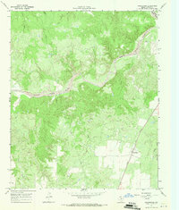
 1967 Dunlap1969 Print · USGSIn the late 1960s, this area of Cottle County was defined by its cattle ranching terrain and the winding Middle Pease River. Researchers can trace the layout of Dunlap, find a local Cem, and see the original extent of the Matador Wildlife Management Area.2 unique versions available
 - 1967 Map of Triangle Ranch, 1969 Print
 1967 Triangle Ranch1969 Print · USGSCottle County ranching country is captured here in the late sixties, showing the vast livestock operations that define this Texas region. Researchers can locate the Ogden (Site), trace family landmarks like Marys Peak, and find remote outposts like Polk Hole Windmill.2 unique versions available
 - 1967 Map of Baker, 1969 Print
 1967 Baker1969 Print · USGSCottle County ranch lands are documented here in the late sixties, where the railroad and river define the northern frontier. Researchers can trace the Quanah Acme and Pacific rail line past Baker or locate the Y L Ranch and its Landing Strip among the creek prongs.2 unique versions available
 - 1967 Map of Northfield, 1969 Print
 1967 Northfield1969 Print · USGSThe West Texas Panhandle near the North Pease River is shown in the late 1960s as a landscape of ranching and river canyons. Genealogists and historians can trace the rural settlement of Northfield or locate family landmarks like Lake Joe and Cheney Mountain.2 unique versions available
 - 1967 Map of Paducah, 1970 Print
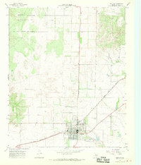 1967 Paducah1970 Print · USGSPaducah and the surrounding Cottle County ranch lands are captured here in the late sixties, showing the town at a crossroads of rail and air. Researchers can trace the QUANAH ACME AND PACIFIC railroad and locate the Garden of Memories (Cem) or the Fairberry Windmill.2 unique versions available
 - 1967 Map of Moons Camp, 1970 Print
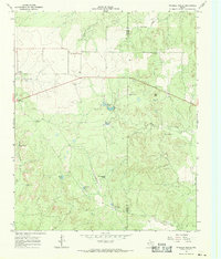
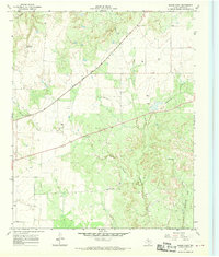 1967 Moons Camp1970 Print · USGSCottle County was a landscape of rail-driven settlements and cattle ranching in the late sixties. Genealogists and historians can trace the Quanah Acme and Pacific rail line through Swearingen and locate landmarks like Moons Camp.2 unique versions available
 - 1967 Map of Swearingen, 1970 Print
 1967 Swearingen1970 Print · USGSCottle County ranch land and river breaks are captured in the late sixties as the local rail economy centered on Swearingen. Genealogists and historians can trace the Quanah Acme and Pacific line and family sites like the small Cem and Drill Hole.
Showing maps 1-25 of 175
Top cities of Cottle County
Frequently asked questions
- What are the different types of historical maps available for Cottle County?
- What is the oldest map of Cottle County?
- Where can I purchase historical maps of Cottle County for my home or office?
- Where can I download high-res historical maps of Cottle County?
- Are there historical topographic maps available for Cottle County?
- Is there historical aerial imagery available for Cottle County?
- Where are historical maps of Cottle County sourced from?