1990s Maps of Cottle County, Texas
Explore 2 historic maps of Cottle County from the 1990s. These maps offer a rare glimpse into what life looked like during the 1990s — showing old roads, neighborhoods, homes, and landmarks that have changed or disappeared over time.
Whether you're researching your family's past, planning a metal detecting trip, or studying how Cottle County's landscape evolved across the 1990s, these high-resolution maps are a powerful tool for exploring the history of this region.
- Focus on a specific era: All maps on this page are from the 1990s, giving you a focused view of this time period.
- See what’s changed: Compare century-old streets, trails, and buildings to today's modern landscape using overlays and satellite layers.
- Research with precision: Use these maps for genealogy, historical research, land use analysis, or educational projects.
- View, download, or print: Maps are fully viewable online in high resolution, and can be downloaded or printed for your own records.
Start exploring Cottle County's history through authentic maps from the 1990s. This is your window into the past.
Cottle County, TX maps
(2)- 1990 Map of Cactus Creek, 1995 Print
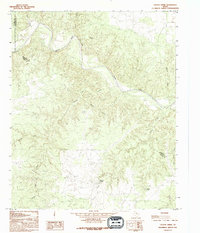 1990 Cactus Creek1995 Print · USGSThe Foard and Hardeman County line in the 1990s was a landscape of deep canyons and seasonal water sources. Local history researchers can trace the winding Pease River and locate vital landmarks like Dripping Springs and Red Bluff.
 - 1990 Map of Goodlett, 1995 Print
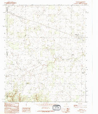 1990 Goodlett1995 Print · USGSThe intersection of Childress, Hardeman, and Cottle counties in North Texas is captured here during the 1990s. Researchers can trace rural settlement patterns through communities like Goodlett and Wheatland or find landmarks such as Hepsidam Hill and Punkin Center.
End of results
Showing maps 1-2 of 2
Top cities of Cottle County
Frequently asked questions
- What are the different types of historical maps available for Cottle County?
- What is the oldest map of Cottle County?
- Where can I purchase historical maps of Cottle County for my home or office?
- Where can I download high-res historical maps of Cottle County?
- Are there historical topographic maps available for Cottle County?
- Is there historical aerial imagery available for Cottle County?
- Where are historical maps of Cottle County sourced from?