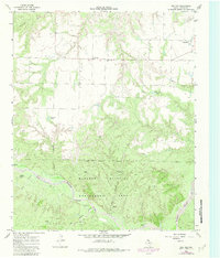
1966 Map of Cee Vee
USGS Topo · Published 1981About this map
The Matador Wildlife Management Area dominates the southern half of this Cottle County landscape, where the Middle Pease River carves a complex drainage network through the West Texas terrain. This mid-century survey reveals a rural economy dependent on scattered water sources, evidenced by the numerous named landmarks like Sick Pen Windmill, Samson Windmill, and Lone Canyon Windmill. The small community of Cee Vee serves as a primary hub for the surrounding ranchlands, with the nearby Haven of Rest Cem providing a critical reference point for genealogists and local historians. North of the wildlife area, the land is marked by numerous draws and creeks including Richland Creek and Bluff Creek, illustrating the transition from open grazing land to the more protected riparian zones of the river valley. The map also identifies the small settlement of Coleyville near the northeastern boundary.
Find a feature on this map
21 named features on this map. Tap any name to fly to it.
Don’t see what you’re looking for? This feature index may not catch every label — zoom into the map to look around manually.
Map Details
Editions of this 1966 Cee Vee Map
2 editions found
Other maps of this area

1954 · Plainview
USGS Topo · 1:250,000

1958 · Plainview
USGS Topo · 1:250,000

1966 · Fields Canyon
USGS Topo · 1:24,000

1966 · Cee Vee
USGS Topo · 1:24,000

1966 · Tee Pee City
USGS Topo · 1:24,000

1966 · Devils Canyon
USGS Topo · 1:24,000

1967 · Tell South
USGS Topo · 1:24,000

1967 · Hell Roaring Creek
USGS Topo · 1:24,000

1967 · Dunlap
USGS Topo · 1:24,000

1967 · Northfield
USGS Topo · 1:24,000