
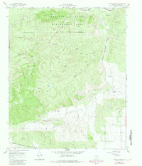
1966 Map of Devils Canyon
USGS Topo · Published 1969About this map
The Matador Wildlife Management Area dominates the northern landscape of this Cottle County quadrangle, where the Middle Pease River and Tongue (South Pease) River converge. This era of land management is characterized by an extensive network of water resources for cattle and wildlife, including the Mouth of River Windmill, China Creek Windmill, and Turkey Tank. The rugged breaks of Devils Canyon and the Red Hills provide sharp relief against the surrounding ranchland.
Find a feature on this map
33 named features on this map. Tap any name to fly to it.
Don’t see what you’re looking for? This feature index may not catch every label — zoom into the map to look around manually.
Map Details
Editions of this 1966 Devils Canyon Map
2 editions found
Other maps of this area

1954 · Lubbock
USGS Topo · 1:250,000

1954 · Plainview
USGS Topo · 1:250,000

1958 · Plainview
USGS Topo · 1:250,000

1966 · Fields Canyon
USGS Topo · 1:24,000

1966 · Cee Vee
USGS Topo · 1:24,000

1966 · Tee Pee City
USGS Topo · 1:24,000

1967 · Dunlap
USGS Topo · 1:24,000

1967 · Paducah
USGS Topo · 1:24,000

1968 · Grow NW
USGS Topo · 1:24,000
1968 · Ginsite
USGS Topo · 1:24,000