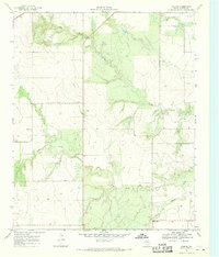
1968 Map of Ginsite
USGS Topo · Published 1970About this map
Ginsite and the rural lands of Cottle County are defined by the convergence of the Wichita River and Buck Creek in this late-1960s topographic survey. The landscape reflects a traditional West Texas ranching and agricultural layout, where isolated landmarks like Harmony Ch and the small settlement of Sneedville serve as primary social anchors. The topography is intricately marked by the drainage patterns of South Buck Creek and Salt Creek, which carve through the plains toward the North Wichita River. Numerous wells are scattered across the quadrangle, indicating the vital importance of groundwater management in this arid region, managed in part by the Texas Water Development Board. These features provide a clear view of the area's infrastructure and community footprint during a period of steady rural development.
Find a feature on this map
12 named features on this map. Tap any name to fly to it.
Don’t see what you’re looking for? This feature index may not catch every label — zoom into the map to look around manually.
Map Details
Editions of this 1968 Ginsite Map
2 editions found
Other maps of this area

1954 · Lubbock
USGS Topo · 1:250,000

1954 · Plainview
USGS Topo · 1:250,000

1958 · Plainview
USGS Topo · 1:250,000

1966 · Chalk SW
USGS Topo · 1:24,000

1966 · Devils Canyon
USGS Topo · 1:24,000

1967 · Paducah
USGS Topo · 1:24,000

1967 · Moons Camp
USGS Topo · 1:24,000

1968 · Grow
USGS Topo · 1:24,000
1968 · Chalk
USGS Topo · 1:24,000

1968 · Buffalo Creek
USGS Topo · 1:24,000