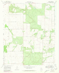
1968 Map of Ginsite
USGS Topo · Published 1981About this map
Buck Creek and Salt Creek carve through the rolling landscape of Cottle County in this 1968 study, which was updated with 1979 aerial data to reflect subtle changes in the terrain. The small community of Ginsite serves as a local focal point alongside Sneedville to the south. These settlements, connected by a network of unimproved and light-duty roads, illustrate the dispersed agricultural nature of the region during the late 1960s. The presence of Harmony Ch suggests a longstanding community center for the surrounding families. In the southern portion of the sheet, the North Wichita River winds across the terrain, highlighting the drainage patterns essential to this part of the Texas panhandle. The map also records mid-century infrastructure developments, such as a prominent Pipeline and a Sewage Disposal site near the northern boundary.
Find a feature on this map
8 named features on this map. Tap any name to fly to it.
Don’t see what you’re looking for? This feature index may not catch every label — zoom into the map to look around manually.
Map Details
Editions of this 1968 Ginsite Map
2 editions found
Other maps of this area

1954 · Lubbock
USGS Topo · 1:250,000

1954 · Plainview
USGS Topo · 1:250,000

1958 · Plainview
USGS Topo · 1:250,000

1966 · Chalk SW
USGS Topo · 1:24,000

1966 · Devils Canyon
USGS Topo · 1:24,000

1967 · Paducah
USGS Topo · 1:24,000

1967 · Moons Camp
USGS Topo · 1:24,000

1968 · Grow
USGS Topo · 1:24,000
1968 · Chalk
USGS Topo · 1:24,000

1968 · Buffalo Creek
USGS Topo · 1:24,000