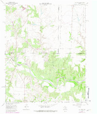
1967 Map of Tell South
USGS Topo · Published 1981About this map
The North Pease River meanders across this landscape in the southeastern Texas Panhandle, defining the shifting boundary between Cottle, Hall, and Childress Counties. The river valley is flanked by several significant drainage systems, including Running Water Creek and Richland Creek, which carve through the plains. This 1967 survey, updated in the late 1970s, captures the agricultural and industrial infrastructure of the region during a period of steady land use. Evidence of local utility and resource extraction is visible through the presence of a Pipeline crossing the northern territory and a Gravel Pit located near the southern bends of the river. To the northwest, smaller waterways like Joe Lake Cr and Devils Creek feed into the broader basin, illustrating the complex hydrologic network of this ranching and farming country.
Find a feature on this map
11 named features on this map. Tap any name to fly to it.
Don’t see what you’re looking for? This feature index may not catch every label — zoom into the map to look around manually.
Map Details
Editions of this 1967 Tell South Map
2 editions found
Other maps of this area

1954 · Plainview
USGS Topo · 1:250,000

1958 · Plainview
USGS Topo · 1:250,000

1966 · Fields Canyon
USGS Topo · 1:24,000

1966 · Cee Vee
USGS Topo · 1:24,000

1967 · Tell South
USGS Topo · 1:24,000

1967 · Hell Roaring Creek
USGS Topo · 1:24,000

1967 · Tell North
USGS Topo · 1:24,000

1967 · Dunlap
USGS Topo · 1:24,000

1967 · Badger Nest Tank
USGS Topo · 1:24,000

1967 · Northfield
USGS Topo · 1:24,000