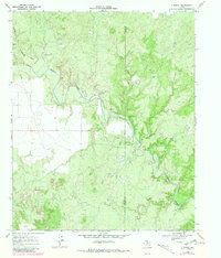
1968 Map of Y Ranch
USGS Topo · Published 1981About this map
The North Wichita River carves a winding path through the borderlands of north Texas, where ranching and energy extraction define the landscape. This 1968 field-checked record, with later aerial revisions, highlights the Y Ranch as the primary focal point of settlement in this part of the Rolling Plains. The terrain is marked by sharp relief along Cottonwood Creek and Coon Hollow Creek, illustrating the natural drainage patterns that have historically shaped land use and property boundaries across the Cottle Co and Foard Co line. Evidence of mid-century industrial activity is present through several labeled Oil Wells and a significant Pipeline, alongside a remote Landing Strip serving the local ranching operations. The inclusion of fence lines and individual structures offers a detailed look at rural infrastructure during a period of transition in the Texas interior.
Find a feature on this map
9 named features on this map. Tap any name to fly to it.
Don’t see what you’re looking for? This feature index may not catch every label — zoom into the map to look around manually.
Map Details
Editions of this 1968 Y Ranch Map
2 editions found

Other maps of this area

1932 · Vivian
USGS Topo · 1:62,500

1954 · Lubbock
USGS Topo · 1:250,000

1954 · Plainview
USGS Topo · 1:250,000

1954 · Wichita Falls
USGS Topo · 1:250,000

1955 · Lawton
USGS Topo · 1:250,000

1958 · Wichita Falls
USGS Topo · 1:250,000

1958 · Plainview
USGS Topo · 1:250,000

1960 · Teacup Mountain
USGS Topo · 1:62,500

1966 · Chalk SW
USGS Topo · 1:24,000

1966 · Big Four Ranch
USGS Topo · 1:24,000