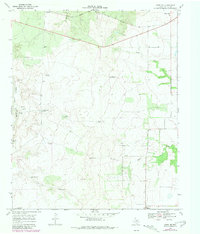
1968 Map of Grow NW
USGS Topo · Published 1981About this map
The Quanah Acme and Pacific railroad cuts across the northern edge of this West Texas landscape, serving as a primary transit artery for the sparse ranching communities of Cottle County. The terrain is defined by the drainage of the Tongue (South Fork Pease) River and the meandering course of Buck Creek and South Buck Creek. Settlement is concentrated at small locales such as Narcisso, Valley View, and Delwin, reflecting the rural, wide-spread nature of Texas cattle country during the late 1960s.
Find a feature on this map
29 named features on this map. Tap any name to fly to it.
Don’t see what you’re looking for? This feature index may not catch every label — zoom into the map to look around manually.
Map Details
Editions of this 1968 Grow NW Map
2 editions found
Other maps of this area

1954 · Lubbock
USGS Topo · 1:250,000

1954 · Plainview
USGS Topo · 1:250,000

1958 · Plainview
USGS Topo · 1:250,000

1966 · Tee Pee City
USGS Topo · 1:24,000

1966 · Devils Canyon
USGS Topo · 1:24,000

1967 · Paducah
USGS Topo · 1:24,000

1968 · Grow
USGS Topo · 1:24,000

1968 · Buffalo Creek
USGS Topo · 1:24,000

1968 · Grow NW
USGS Topo · 1:24,000

1968 · Dumont
USGS Topo · 1:24,000