
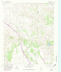
1963 Map of Giles
USGS Topo · Published 1966About this map
The Fort Worth and Denver railroad cuts diagonally across this Texas Panhandle landscape, serving as a primary corridor through the rolling hills of Donley County. Small settlements like Giles and Bain sit along the tracks and highway, marking the cattle and transport hubs of the early 1960s. The terrain is deeply etched by a network of seasonal waterways including Parker Creek, Jonah Creek, and the South Fork of the Red River, which flow toward the Donley and Collingsworth county boundary.
Find a feature on this map
19 named features on this map. Tap any name to fly to it.
Don’t see what you’re looking for? This feature index may not catch every label — zoom into the map to look around manually.
Map Details
Editions of this 1963 Giles Map
2 editions found
Other maps of this area

1954 · Plainview
USGS Topo · 1:250,000

1958 · Plainview
USGS Topo · 1:250,000

1959 · Lelia Lake Creek
USGS Topo · 1:24,000

1959 · McKnight
USGS Topo · 1:24,000

1961 · Memphis
USGS Topo · 1:62,500

1961 · Estelline
USGS Topo · 1:62,500

1963 · Hedley
USGS Topo · 1:24,000

1964 · Rolla SW
USGS Topo · 1:24,000

1964 · Quail
USGS Topo · 1:24,000

1976 · Memphis NW
USGS Topo · 1:24,000