
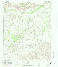
1959 Map of McKnight
USGS Topo · Published 1960About this map
Salt Fork Red River dominates the northern reaches of this Panhandle landscape, where the braided riverbed meets the sharp relief of Whitefish Creek and Oklahoma Draw. This 1959 field check captures a transitional agricultural and ranching environment along the approximate boundary of Donley and Collingsworth counties. The small settlement of Mc Knight serves as a local focal point, connected to the surrounding rural community by a network of unimproved roads and light-duty routes. To the northeast, the Ring Ch stands as a spiritual center for the area's residents, while the presence of a Gravel Pit and a crossing Pipeline indicates the quiet industrial activity and infrastructure supporting the region during the late 1950s. The terrain is defined by dramatic erosion features like Jesse Arroyo, reflecting the character of the eastern Panhandle plains.
Find a feature on this map
11 named features on this map. Tap any name to fly to it.
Don’t see what you’re looking for? This feature index may not catch every label — zoom into the map to look around manually.
Map Details
Editions of this 1959 McKnight Map
2 editions found
Other maps of this area

1954 · Amarillo
USGS Topo · 1:250,000

1954 · Plainview
USGS Topo · 1:250,000

1958 · Amarillo
USGS Topo · 1:250,000

1958 · Plainview
USGS Topo · 1:250,000

1959 · Lelia Lake Creek
USGS Topo · 1:24,000

1959 · Troublesome Creek
USGS Topo · 1:24,000

1959 · Spencer Lake
USGS Topo · 1:24,000

1963 · Hedley
USGS Topo · 1:24,000

1963 · Giles
USGS Topo · 1:24,000

1964 · Rolla SW
USGS Topo · 1:24,000