
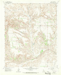
1964 Map of Quail
USGS Topo · Published 1967About this map
Quail serves as the primary hub of this landscape in Collingsworth County, where the grid of rural roads and section lines dictates the organization of the terrain. The community includes the Quail Cemetery and a local Athletic Field, suggesting a established center for the surrounding agricultural community during the mid-1960s. To the north, the small settlement of Marilla sits along the road network, while the natural topography is defined by the winding course of Dry Hollow. This survey provides a precise record of land divisions and property boundaries, marked by fine red dashed lines that indicate selected fence lines across the open country.
Find a feature on this map
5 named features on this map. Tap any name to fly to it.
Don’t see what you’re looking for? This feature index may not catch every label — zoom into the map to look around manually.
Map Details
Editions of this 1964 Quail Map
This is the sole edition of this map. No revisions or reprints were ever made.
Other maps of this area

1954 · Amarillo
USGS Topo · 1:250,000

1954 · Plainview
USGS Topo · 1:250,000

1958 · Amarillo
USGS Topo · 1:250,000

1958 · Plainview
USGS Topo · 1:250,000

1959 · Spencer Lake
USGS Topo · 1:24,000

1959 · McKnight
USGS Topo · 1:24,000

1963 · Giles
USGS Topo · 1:24,000

1964 · Rolla SW
USGS Topo · 1:24,000

1964 · Rolla NE
USGS Topo · 1:24,000
1964 · Abra
USGS Topo · 1:24,000