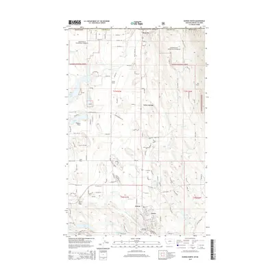
2014 Map of Eureka North
USGS Topo · Published 2014About this map
Roosville sits prominently at the northern edge of this map, marking a primary entry point between the United States and Canada in Northwest Montana. This 2014 survey captures the community of Eureka and its surrounding rural infrastructure, from the Eureka Airport to the Eureka Cem. The landscape is defined by the Tobacco River, which is crossed by the Tobacco River Bridge and the Saint Clair Creek Bridge as it flows toward the southwest.
Find a feature on this map
133 named features on this map. Tap any name to fly to it.
Don’t see what you’re looking for? This feature index may not catch every label — zoom into the map to look around manually.
Map Details
Editions of this 2014 Eureka North Map
This is the sole edition of this map. No revisions or reprints were ever made.
Other maps of this area

1913 · Stryker
USGS Topo · 1:125,000

1916 · Stryker
USGS Topo · 1:125,000

1957 · Kalispell
USGS Topo · 1:250,000

1960 · Kalispell
USGS Topo · 1:250,000

1961 · Kalispell
USGS Topo · 1:250,000

1963 · Rexford
USGS Topo · 1:24,000

1963 · Eureka North
USGS Topo · 1:24,000

1963 · Ksanka Peak
USGS Topo · 1:24,000

1963 · Eureka South
USGS Topo · 1:24,000
1963 · Fortine
USGS Topo · 1:24,000