
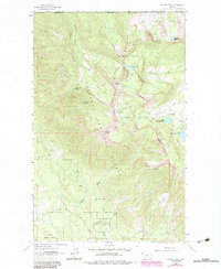
1963 Map of Ksanka Peak
USGS Topo · Published 1966About this map
The Galton Range dominates this mid-century survey of the high mountain terrain along the international border, where the British Columbia Montana boundary line meets the Kootenay District Lincoln Co divide. This is a landscape shaped by glacial basins and isolated peaks, containing high-elevation water bodies like Bluebird Lake and the distinctive Ten Lakes Basin.
Find a feature on this map
36 named features on this map. Tap any name to fly to it.
Don’t see what you’re looking for? This feature index may not catch every label — zoom into the map to look around manually.
Map Details
Editions of this 1963 Ksanka Peak Map
2 editions found
Other maps of this area

1913 · Stryker
USGS Topo · 1:125,000

1916 · Stryker
USGS Topo · 1:125,000

1957 · Kalispell
USGS Topo · 1:250,000

1960 · Kalispell
USGS Topo · 1:250,000

1961 · Kalispell
USGS Topo · 1:250,000

1963 · Eureka North
USGS Topo · 1:24,000

1963 · Mount Marston
USGS Topo · 1:24,000

1963 · Eureka South
USGS Topo · 1:24,000

1963 · Stahl Peak
USGS Topo · 1:24,000
1963 · Fortine
USGS Topo · 1:24,000