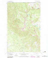
1963 Map of Ksanka Peak
USGS Topo · Published 1984About this map
The Galton Range dominates this landscape in the northern reaches of the Kootenai National Forest, just below the international border with Canada. Centered on Ksanka Peak, the terrain is defined by a series of high-elevation cirques and basins, most notably the Ten Lakes Basin and Poorman Basin. These basins serve as the headwaters for numerous drainages, including Bluebird Creek and Wolverine Creek, which flow through heavily forested slopes toward the valley floors.
Find a feature on this map
38 named features on this map. Tap any name to fly to it.
Don’t see what you’re looking for? This feature index may not catch every label — zoom into the map to look around manually.
Map Details
Editions of this 1963 Ksanka Peak Map
2 editions found
Other maps of this area

1913 · Stryker
USGS Topo · 1:125,000

1916 · Stryker
USGS Topo · 1:125,000

1957 · Kalispell
USGS Topo · 1:250,000

1960 · Kalispell
USGS Topo · 1:250,000

1961 · Kalispell
USGS Topo · 1:250,000

1963 · Eureka North
USGS Topo · 1:24,000

1963 · Mount Marston
USGS Topo · 1:24,000

1963 · Ksanka Peak
USGS Topo · 1:24,000

1963 · Eureka South
USGS Topo · 1:24,000

1963 · Stahl Peak
USGS Topo · 1:24,000