
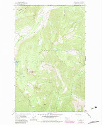
1963 Map of Stahl Peak
USGS Topo · Published 1966About this map
Kootenai National Forest dominates this 1960s survey of the northern Montana borderlands, where the British Columbia Montana line defines the northern boundary. The high-altitude landscape of the Ten Lakes Basin is marked by a network of drainage systems including the Wigwam River and Grave Creek. At an elevation of 7451 feet, Stahl Peak serves as a primary landmark, featuring a lookout and proximity to the remote Therriault Pass.
Find a feature on this map
36 named features on this map. Tap any name to fly to it.
Don’t see what you’re looking for? This feature index may not catch every label — zoom into the map to look around manually.
Map Details
Editions of this 1963 Stahl Peak Map
2 editions found
Other maps of this area

1913 · Stryker
USGS Topo · 1:125,000

1916 · Stryker
USGS Topo · 1:125,000

1957 · Kalispell
USGS Topo · 1:250,000

1960 · Kalispell
USGS Topo · 1:250,000

1961 · Kalispell
USGS Topo · 1:250,000

1963 · Mount Marston
USGS Topo · 1:24,000

1963 · Ksanka Peak
USGS Topo · 1:24,000
1963 · Fortine
USGS Topo · 1:24,000
1966 · Mount Thompson-Seton
USGS Topo · 1:24,000
1966 · Tuchuck Mountain
USGS Topo · 1:24,000