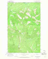
1966 Map of Tuchuck Mountain
USGS Topo · Published 1971About this map
The Kootenai National Forest and Flathead National Forest converge at the international boundary in this 1966 field survey of the high country north of Eureka. The landscape is defined by the high-elevation divide between Lincoln and Flathead Counties, where steep drainages like Nokio Creek and Yakinikak Creek flow from the ridges. A primitive human footprint is evident in the network of labeled Pack Trails that cross Seemo Pass and connect remote outposts such as Weasel Cabin. Significant summits including Tuchuck Mountain and Mount Lewis dominate the topography, while smaller alpine features like Weasel Lake and Timothy Meadow provide specific landmarks for those navigating the backcountry. This map serves as a detailed record of the wilderness just south of the British Columbia border, capturing the drainage patterns of Seemo Creek and Kootah Creek before modern forest management altered these corridors.
Find a feature on this map
33 named features on this map. Tap any name to fly to it.
Don’t see what you’re looking for? This feature index may not catch every label — zoom into the map to look around manually.
Map Details
Editions of this 1966 Tuchuck Mountain Map
This is the sole edition of this map. No revisions or reprints were ever made.
Other maps of this area

1913 · Stryker
USGS Topo · 1:125,000

1916 · Stryker
USGS Topo · 1:125,000

1957 · Kalispell
USGS Topo · 1:250,000

1960 · Kalispell
USGS Topo · 1:250,000

1961 · Kalispell
USGS Topo · 1:250,000

1963 · Mount Marston
USGS Topo · 1:24,000

1963 · Stahl Peak
USGS Topo · 1:24,000

1966 · Red Meadow Lake
USGS Topo · 1:24,000

1966 · Mount Hefty
USGS Topo · 1:24,000
1966 · Mount Thompson-Seton
USGS Topo · 1:24,000