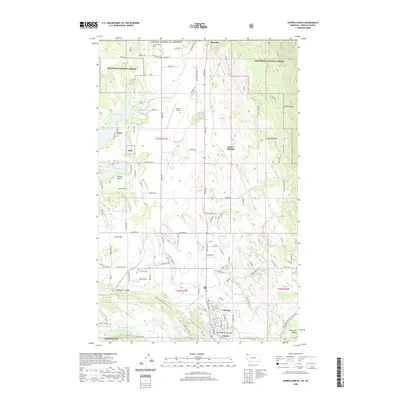
2020 Map of Eureka North
USGS Topo · Published 2020About this map
Roosville stands as a primary crossing point on the international border, anchoring the northern edge of this Montana landscape. The southern portion of the map centers on the community of Eureka, where the Tobacco River is spanned by the Tobacco River Bridge and Saint Clair Creek Bridge. The settlement pattern follows the fertile Tobacco Plains and Iowa Flats, with residential clusters appearing at Midvale and Indian Springs. Local infrastructure is well-defined, including the Eureka Airport and the Eureka Cem, while the rugged eastern and western reaches are defined by the Galton Range and Whitefish Range. This map documents a region where recreational and conservation lands, such as the Kootenai National Forest and the Pacific NW National Scenic Trail, interface with established agricultural and township layouts.
Find a feature on this map
52 named features on this map. Tap any name to fly to it.
Don’t see what you’re looking for? This feature index may not catch every label — zoom into the map to look around manually.
Map Details
Editions of this 2020 Eureka North Map
This is the sole edition of this map. No revisions or reprints were ever made.
Other maps of this area

1913 · Stryker
USGS Topo · 1:125,000

1916 · Stryker
USGS Topo · 1:125,000

1957 · Kalispell
USGS Topo · 1:250,000

1960 · Kalispell
USGS Topo · 1:250,000

1961 · Kalispell
USGS Topo · 1:250,000

1963 · Rexford
USGS Topo · 1:24,000

1963 · Eureka North
USGS Topo · 1:24,000

1963 · Ksanka Peak
USGS Topo · 1:24,000

1963 · Eureka South
USGS Topo · 1:24,000
1963 · Fortine
USGS Topo · 1:24,000