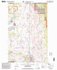
1997 Map of Eureka North
USGS Topo · Published 2000About this map
The Tobacco Plains of Lincoln County, Montana, define this northern borderland area where the United States meets Canada. In the late 20th century, the landscape is a mix of agricultural flats and timbered slopes of the Kootenai National Forest. The town of Eureka serves as the local hub, supported by the Tobacco River and a network of creeks including Ksanka Creek and Sinclair Creek. Near the international boundary, Roosville and its Roosville PO mark the port of entry adjacent to the US Customs station.
Find a feature on this map
39 named features on this map. Tap any name to fly to it.
Don’t see what you’re looking for? This feature index may not catch every label — zoom into the map to look around manually.
Map Details
Editions of this 1997 Eureka North Map
This is the sole edition of this map. No revisions or reprints were ever made.
Other maps of this area

1913 · Stryker
USGS Topo · 1:125,000

1916 · Stryker
USGS Topo · 1:125,000

1957 · Kalispell
USGS Topo · 1:250,000

1960 · Kalispell
USGS Topo · 1:250,000

1961 · Kalispell
USGS Topo · 1:250,000

1963 · Rexford
USGS Topo · 1:24,000

1963 · Eureka North
USGS Topo · 1:24,000

1963 · Ksanka Peak
USGS Topo · 1:24,000

1963 · Eureka South
USGS Topo · 1:24,000
1963 · Fortine
USGS Topo · 1:24,000