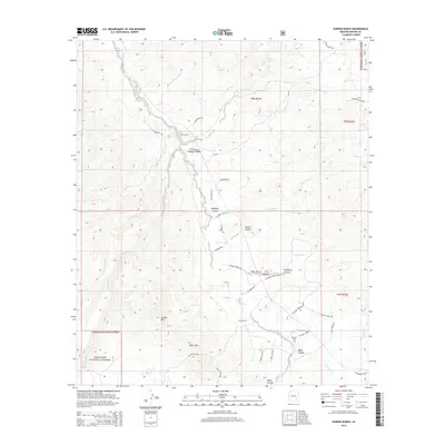
2014 Map of Eureka Ranch
USGS Topo · Published 2014About this map
Eureka Ranch serves as a central landmark in this remote corner of Graham County, where the high desert terrain is carved by the deep drainage of Aravaipa Creek. This 2014 survey reveals a landscape of isolated canyons and family burial grounds, including Whalen Cem, Johns Cem, and Kennedy Cem, which point to a long history of cattle ranching and homesteading. To the south, the Black Hills rise near Eureka Mtn, with much of the land falling within the protected bounds of the Coronado National Forest. The map is characterized by a dense network of primitive roads and named trails, such as W Four Feathers Loop and S Red Cloud Trl, that navigate the complex topography of Black Canyon and President Canyon. The seasonal nature of the environment is reflected in features like Walnut Spring and Mills Tank, which are vital water sources in this arid region.
Find a feature on this map
51 named features on this map. Tap any name to fly to it.
Don’t see what you’re looking for? This feature index may not catch every label — zoom into the map to look around manually.
Map Details
Editions of this 2014 Eureka Ranch Map
This is the sole edition of this map. No revisions or reprints were ever made.
Other maps of this area

1938 · Galiuro Mts
USGS Topo · 1:48,000

1938 · Klondyke
USGS Topo · 1:48,000

1940 · Sierra Bonita Ranch
USGS Topo · 1:62,500

1942 · Sierra Bonita Ranch
USGS Topo · 1:62,500

1943 · Galiuro Mts
USGS Topo · 1:62,500

1943 · Klondyke
USGS Topo · 1:62,500

1943 · Sierra Bonita Ranch
USGS Topo · 1:62,500

1944 · Jackson Mtn.
USGS Topo · 1:62,500

1946 · Jackson Mtn.
USGS Topo · 1:62,500

1956 · Tucson
USGS Topo · 1:250,000