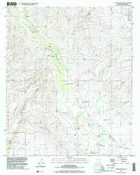
1996 Map of Eureka Ranch
USGS Topo · Published 2002About this map
Aravaipa Canyon carves a deep path through this Graham County landscape, where the seasonal waters of Aravaipa Creek and Kennedy Falls Wash dictate the pattern of human settlement. Ranching and water management are the primary activities documented here, evidenced by the scattered distribution of private operations like River Calderan Ranch and numerous named water sources such as the Paddy Lynch Windmill, Bull Pasture Windmill, and Birdcage Windmill.
Find a feature on this map
31 named features on this map. Tap any name to fly to it.
Don’t see what you’re looking for? This feature index may not catch every label — zoom into the map to look around manually.
Map Details
Editions of this 1996 Eureka Ranch Map
This is the sole edition of this map. No revisions or reprints were ever made.
Other maps of this area

1938 · Galiuro Mts
USGS Topo · 1:48,000

1938 · Klondyke
USGS Topo · 1:48,000

1940 · Sierra Bonita Ranch
USGS Topo · 1:62,500

1942 · Sierra Bonita Ranch
USGS Topo · 1:62,500

1943 · Galiuro Mts
USGS Topo · 1:62,500

1943 · Klondyke
USGS Topo · 1:62,500

1943 · Sierra Bonita Ranch
USGS Topo · 1:62,500

1944 · Jackson Mtn.
USGS Topo · 1:62,500

1946 · Jackson Mtn.
USGS Topo · 1:62,500

1956 · Tucson
USGS Topo · 1:250,000