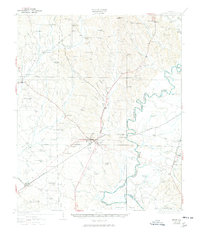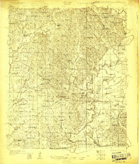
1927 Map of Eutaw
USGS Topo · Published 1927About this map
Eutaw serves as the focal point of this Greene County landscape, situated just west of the winding Black Warrior River during the late 1920s. The map illustrates a rural society deeply connected to its land and water, with river-based transit points like Forches Ferry and Parhams Landing providing critical links between Greene and Hale Counties. The settlement pattern is defined by a high density of country schools and churches, such as the Rosenwald School and Jerusalem Church, which suggest the social structure of localized agricultural communities.
Find a feature on this map
87 named features on this map. Tap any name to fly to it.
Don’t see what you’re looking for? This feature index may not catch every label — zoom into the map to look around manually.
Map Details
Editions of this 1927 Eutaw Map
This is the sole edition of this map. No revisions or reprints were ever made.
Historical Maps of Eutaw Through Time
8 maps found