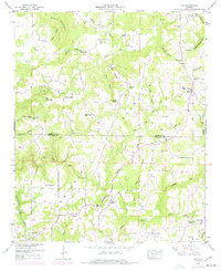
1949 Map of Eva
USGS Topo · Published 1977About this map
The Tennessee Valley Divide snakes through the center of this rural landscape, separating the drainage of East Fork Flint Creek and the Lick Creek basin. The area is defined by the high ground of Negro Mountain and Cook Gap Mountain, with several small settlements clustered along the ridges and valley floors. To the south, the Louisville and Nashville railroad serves the community of Vinemont, while the northern portion of the map features the dispersed community of Eva and the upland hamlet of Oden Ridge. Numerous country churches and family burial grounds, such as Hamby Chapel Church, Ebenezer Ch, and Childers Cem, are scattered throughout the hills, providing a detailed look at the social geography of this region in the late 1940s before modern development and highway expansions altered the character of the Morgan and Cullman County borderlands.
Find a feature on this map
58 named features on this map. Tap any name to fly to it.
Don’t see what you’re looking for? This feature index may not catch every label — zoom into the map to look around manually.
Map Details
Editions of this 1949 Eva Map
This is the sole edition of this map. No revisions or reprints were ever made.
Other maps of this area

1888 · Cullman
USGS Topo · 1:125,000

1892 · Cullman
USGS Topo · 1:125,000

1927 · Falkville
USGS Topo · 1:24,000

1936 · Hartselle
USGS Topo · 1:24,000

1936 · Eva
USGS Topo · 1:24,000

1936 · Somerville
USGS Topo · 1:24,000

1936 · Lawrence Cove
USGS Topo · 1:24,000

1936 · Center Grove
USGS Topo · 1:24,000
1947 · Center Grove
USGS Topo · 1:24,000

1949 · Falkville
USGS Topo · 1:24,000