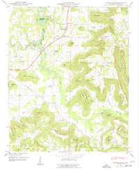
1947 Map of Center Grove
USGS Topo · Published 1977About this map
Wheeler Reservoir defines the northwest corner of this landscape, its waters reaching into the valleys near Woodland Mills. The terrain transitions sharply from the level reservoir boundary into the rising slopes of Brindlee Mountain and Georgia Mountain, creating a complex network of coves and hollows. This 1946 topography, examined in the field by the Tennessee Valley Authority in 1947, reveals a rural economy centered on upland settlements like Center Grove and Florette.
Find a feature on this map
73 named features on this map. Tap any name to fly to it.
Don’t see what you’re looking for? This feature index may not catch every label — zoom into the map to look around manually.
Map Details
Editions of this 1947 Center Grove Map
3 editions found
Other maps of this area

1888 · Cullman
USGS Topo · 1:125,000

1888 · Huntsville
USGS Topo · 1:125,000

1892 · Cullman
USGS Topo · 1:125,000

1892 · Huntsville
USGS Topo · 1:125,000

1936 · Triana
USGS Topo · 1:24,000

1936 · Hulaco
USGS Topo · 1:24,000

1936 · Eva
USGS Topo · 1:24,000

1936 · Somerville
USGS Topo · 1:24,000

1936 · Lawrence Cove
USGS Topo · 1:24,000

1936 · Center Grove
USGS Topo · 1:24,000