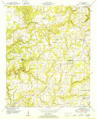
1951 Map of Eva
USGS Topo · Published 1951About this map
Negro Mountain and the Tennessee Valley Divide define the topography of this corner of north Alabama, where the landscape transitions between the Tennessee and Warrior River basins. The 1951 survey reveals a rural society structured around numerous small congregations and family burial grounds, including Hills Chapel, Hamby Chapel Cem, and Mt Carmel Church. The presence of Stillhouse Hollow and several named coves like Gandy Cove suggest a history of secluded agriculture and timber harvesting within the undulating terrain.
Find a feature on this map
58 named features on this map. Tap any name to fly to it.
Don’t see what you’re looking for? This feature index may not catch every label — zoom into the map to look around manually.
Map Details
Editions of this 1951 Eva Map
This is the sole edition of this map. No revisions or reprints were ever made.
Other maps of this area

1888 · Cullman
USGS Topo · 1:125,000

1892 · Cullman
USGS Topo · 1:125,000

1927 · Falkville
USGS Topo · 1:24,000

1936 · Hartselle
USGS Topo · 1:24,000

1936 · Eva
USGS Topo · 1:24,000

1936 · Somerville
USGS Topo · 1:24,000

1936 · Lawrence Cove
USGS Topo · 1:24,000

1936 · Center Grove
USGS Topo · 1:24,000
1947 · Center Grove
USGS Topo · 1:24,000

1949 · Falkville
USGS Topo · 1:24,000