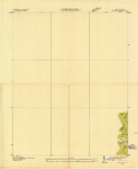
1935 Map of Evarts
USGS Topo · Published 1935About this map
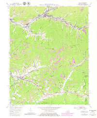
Kentucky Virginia Boundary lines define this corner of the Appalachians as surveyed in the mid-1930s by the Tennessee Valley Authority. The map focuses on a specific transition zone where the Harlan Lee county lines meet the high topography of the Ridge line. This advance sheet represents an early topographic study of the Jefferson National Forest area, capturing the early industrial infrastructure of the region through the Ky Util Co Trans Line and the presence of Nolansburg No 1. The drainage of Stone Creek illustrates the rugged drainage patterns that dictated the placement of early settlements and utility corridors during this era of federal expansion and resource management.
Find a feature on this map
7 named features on this map. Tap any name to fly to it.
Don’t see what you’re looking for? This feature index may not catch every label — zoom into the map to look around manually.
Map Details
Editions of this 1935 Evarts Map
This is the sole edition of this map. No revisions or reprints were ever made.
Historical Maps of Evarts Through Time
8 maps found