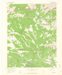
1960 Map of Evergreen
USGS Topo · Published 1960About this map
Evergreen is the focal point of this 1960 survey, situated at the confluence of Bear Creek and Evergreen Lake. The landscape transition from the high peaks of Jenkins Peak and Independence Mountain down through the winding Mount Vernon Canyon reveals a mid-century community balancing residential growth with extensive public parkland. Large recreational and conservation areas such as Genesee Park, O'Fallon Park, and Dedisse Park dominate the terrain, reflecting the area's development as a mountain retreat for the nearby Denver region.
Find a feature on this map
50 named features on this map. Tap any name to fly to it.
Don’t see what you’re looking for? This feature index may not catch every label — zoom into the map to look around manually.
Map Details
Editions of this 1960 Evergreen Map
This is the sole edition of this map. No revisions or reprints were ever made.
Other maps of this area

1899 · West Denver
USGS Topo · 1:125,000

1906 · Blackhawk
USGS Topo · 1:62,500

1938 · Morrison
USGS Topo · 1:24,000

1939 · Golden
USGS Topo · 1:24,000

1942 · Morrison
USGS Topo · 1:31,680

1942 · Golden
USGS Topo · 1:31,680

1942 · Black Hawk
USGS Topo · 1:24,000

1942 · Ralston Buttes
USGS Topo · 1:24,000

1944 · Black Hawk
USGS Topo · 1:31,680
1944 · Ralston Buttes
USGS Topo · 1:31,680