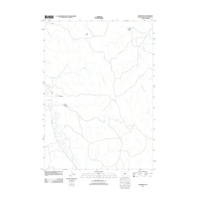
2012 Map of Evergreen
USGS Topo · Published 2012About this map
The community of Evergreen is situated within a landscape of deep canyons and prominent ridges in South Dakota's Shannon County. The terrain is defined by dramatic elevations such as Bell Butte and the winding Crooked Eyes Canyon to the north. Water sources are vital to this semi-arid region, evidenced by the inclusion of Iron Cloud Spring and several seasonal drainage systems like Porcupine Cr and Threemile Cr. Notable for local history and heritage, the map identifies the Big Foot Trl and a Fire Trl, indicating both the cultural significance of the land and the modern management of its natural resources. The spatial distribution of family-named features like Iron Cloud Canyon reflects the deep connection between the indigenous population and specific landmarks throughout the Pine Ridge area.
Find a feature on this map
10 named features on this map. Tap any name to fly to it.
Don’t see what you’re looking for? This feature index may not catch every label — zoom into the map to look around manually.
Map Details
Editions of this 2012 Evergreen Map
This is the sole edition of this map. No revisions or reprints were ever made.
Other maps of this area

1951 · Sharps Corner
USGS Topo · 1:24,000

1955 · Hot Springs
USGS Topo · 1:250,000

1967 · Manderson
USGS Topo · 1:24,000

1967 · Wounded Knee
USGS Topo · 1:24,000

1981 · Yellow Bear Camp
USGS Topo · 1:25,000

1981 · Kyle
USGS Topo · 1:25,000

1981 · Evergreen
USGS Topo · 1:25,000
1981 · Batesland
USGS Topo · 1:25,000

1981 · Evergreen NE
USGS Topo · 1:24,000

1985 · Pine Ridge
USGS Topo · 1:100,000