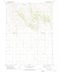
1972 Map of Fairchild Ranch
USGS Topo · Published 1975About this map
Fairchild Ranch and the nearby settlement of Fairchild anchor this high-plains landscape in western Nebraska. This 1970s topographical record captures the sparse, working nature of the borderlands between Morrill County and Cheyenne County, where the terrain transitions from the broken draws of Cedar Creek in the north to the flatter agricultural and grazing lands to the south. The map documents essential infrastructure for this rural economy, including a long Pipeline cutting diagonally across the southern townships and several localized industrial sites such as a Gravel Pit. To the southeast, the outlier of Sidney and the Radio Tower mark the modern development of the era, while scattered water sources like the Springs near the northern boundary indicate the vital importance of groundwater in this arid environment.
Find a feature on this map
12 named features on this map. Tap any name to fly to it.
Don’t see what you’re looking for? This feature index may not catch every label — zoom into the map to look around manually.
Map Details
Editions of this 1972 Fairchild Ranch Map
This is the sole edition of this map. No revisions or reprints were ever made.
Other maps of this area

1896 · Browns Creek
USGS Topo · 1:125,000

1899 · Browns Creek
USGS Topo · 1:125,000

1899 · Sidney
USGS Topo · 1:125,000

1954 · Scottsbluff
USGS Topo · 1:250,000

1958 · Scottsbluff
USGS Topo · 1:250,000

1965 · Broadwater
USGS Topo · 1:24,000

1965 · Broadwater SW
USGS Topo · 1:24,000

1971 · Tar Valley SW
USGS Topo · 1:24,000

1972 · Lisco NW
USGS Topo · 1:24,000

1972 · Gurley
USGS Topo · 1:24,000