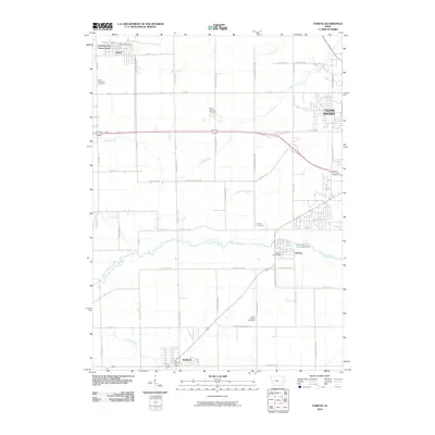
2010 Map of Fairfax
USGS Topo · Published 2010About this map
Fairfax and Atkins anchor this agricultural and suburban landscape just west of the expanding Cedar Rapids metro area. The terrain is defined by the winding paths of Prairie Creek, Morgan Creek, and Silver Creek, which bisect a grid of rural roads and emerging residential developments. Significant for genealogists and local historians, the sheet identifies several prominent burial grounds, including Saint Stephens Cemetery, Saint Joseph Cemetery, Fairfax Cemetery, and Saint Patricks Cemetery, often situated near early church or family settlement sites. Local postal centers like the Atkins Post Office, Fairfax Post Office, and Walford Post Office mark the civic hubs for these communities. The map captures the transition of Linn County’s landscape as traditional farmsteads and creek valleys meet modern infrastructure, including the Country Aire Home Park and the burgeoning suburban reaches of Cedar Rapids.
Find a feature on this map
52 named features on this map. Tap any name to fly to it.
Don’t see what you’re looking for? This feature index may not catch every label — zoom into the map to look around manually.
Map Details
Editions of this 2010 Fairfax Map
This is the sole edition of this map. No revisions or reprints were ever made.
Other maps of this area

1887 · Cedar Rapids
USGS Topo · 1:62,500

1888 · Shellsburg
USGS Topo · 1:62,500

1888 · Marion
USGS Topo · 1:62,500

1888 · Amana
USGS Topo · 1:62,500

1889 · Marion
USGS Topo · 1:62,500

1889 · Amana
USGS Topo · 1:62,500

1889 · Shellsburg
USGS Topo · 1:62,500

1891 · Cedar Rapids
USGS Topo · 1:62,500

1899 · Amana
USGS Topo · 1:62,500

1899 · Shellsburg
USGS Topo · 1:62,500